

Housed in a sleek new building just over the levee near downtown Baton Rouge is a scale model of the lower Mississippi River Delta. Researchers use it to study how sediment moves through the river. State officials, environmental groups, and lawmakers use it to advocate for coastal restoration projects. As land along Louisiana’s coastline continues to disappear at faster and faster rates, the model could help shape the future of the region and provide valuable lessons for coastal communities across the world.
It’s no secret that Louisiana’s coast is changing and many of the state’s coastal wetlands are subsiding, the technical term for sinking. It’s not a mystery why it’s happening, either.
“Because the Mississippi River floods each year and wants to change its course, we built levees on either side of its banks,” said Bren Haase, executive director of Louisiana’s Coastal Restoration and Protection Authority (CPRA). “Those levees have had real benefits to the United States and the State of Louisiana in terms of navigation and flood control, but they’ve also had real negative impacts to our coastal communities, leaving them much more vulnerable to things like saltwater intrusion, subsidence, sea level rises and storm surges.”
This also isn’t exactly new information.
An 1897 National Geographic article, “The Delta of the Mississippi River,” warned of the “effect of withholding by the levees from the great areas of the delta of the annual contributions of sedimentary matters,” saying it would lead to “subsidence of the Gulf delta lands below the level of the sea and their gradual abandonment due to this cause.”

The article went on to say that while the “development of the delta country” would lead to land subsidence, the economic benefit “far outweighs the disadvantages to future generations.” The benefits would be “so remarkable,” the article asserted, that “the people of the whole United States can well afford, when the time comes, to build a protective levee against the Gulf waters.” Almost 125 years after that article was published, its predictions of the environmental impacts of overdevelopment have come to fruition, but federal funding for coastal restoration projects may be lacking.
The land is also sinking faster than recent estimates said it would. A 2017 study by Tulane University geologists found that the average subsidence rate along the Louisiana coast is around nine millimeters a year, or more than one-third of an inch. That’s much higher than the rate averaged between one and six millimeters per year found in previous studies.
In some spots, the subsidence rate is as high as 12 millimeters per year, or nearly a half-inch. “We’ve been losing coastal land at the rate of a football field every 90 minutes,” Haase said.
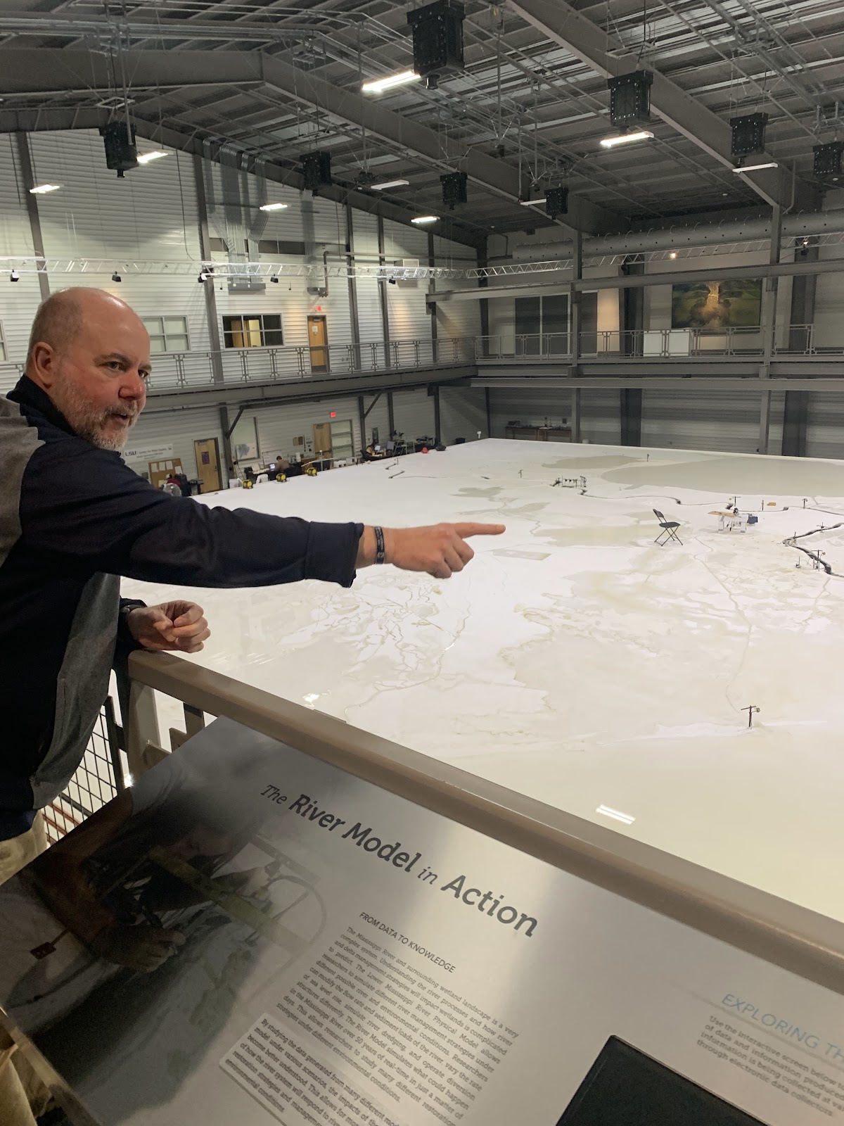
While most Louisianans likely know about at least some of the problems facing the state’s coastal wetlands (almost everyone has heard the “football field” analogy), few know about the Lower Mississippi River Physical Model, a 10,000 square foot model housed at the LSU Center for River Studies on the Baton Rouge Water Campus near the banks of the Mississippi River in Baton Rouge.

Constructed of 216 high-density foam panels that match the exact topography of the region and using 20 high-definition projectors to create a dazzling visual display, the model brings the river and coast to life. It’s essentially a replica of the lower Mississippi River Delta, down to the last bayou, levee, and channel. Using real-time data collected from U.S. Army Corps of Engineers river gages that measure water levels on the real Mississippi River, researchers pump water filled with lightweight plastic particles that simulate sediment into the model to run simulations and look into the future of the state.
“When we put those particles in our model river, they move down the model river the way sand moves down the Mississippi River,” said Clint Willson, director of the LSU Center for River Studies. “One hour on the model is about one year on the river. So that means every 65 seconds on the model is five days in the real world.”
Willson said researchers use the model to look into the river’s future. “The objective is to study the way sand moves down the river within a year, and then two years, five years, 10 years, 25 years, and 50 years.”
That 50-year mark is important because of Louisiana’s “coastal master plan.” Every five years the state produces a science and engineering-based plan to prioritize coastal restoration projects based on their ability to build land, maintain land, or reduce the risk of flooding. “They do that with the idea that over 50 years, they can decide which projects are the most effective,” Willson said.
To help determine which projects are a higher priority as they’re crafting the coastal master plan, state lawmakers and officials from the CPRA often visit the LSU Center for River Studies, where they can get a larger perspective of coastal Louisiana. “We’ll bring people here first, talk about the big picture, talk about the river, the coast, talk about the projects that are happening. And then they’ll go out into the field and go to a specific project site,” said Willson.
That perspective can be an invaluable tool, especially for out-of-state visitors. “The really cool thing about the model when you see it is that coastal Louisiana is really hard to get to. It’s really hard to take someone from Iowa and show them the coast,” said Amy Wold, director of communication at The Water Institute of the Gulf, an independent non-profit applied research organization that works to help solve complex environmental challenges. “You can take them to this place and they have these fantastic animations that really give them an idea of what’s going on. It gives a big picture, which was impossible to do before this.”
Wold said taking people who aren’t from the region through the facility and showing them the river model helps drive the point home and illustrates that what happens in coastal Louisiana affects the rest of the country. “People think of it as Louisiana problems,” Wold said. “These are nationwide impacts from the challenges we’re facing here. You knock out the oil and gas in coastal Louisiana, you’re going to see gas prices rise. You want your shipping to continue, we’ve got to keep this dredged. And to keep it dredged also means keeping it surrounded by wetlands. Those are connected. So it’s giving people an idea that losing wetlands isn’t just sad for us, it’s sad for all of us. We’re all in this together.”
The river model isn’t just a useful visual or educational tool for state officials or nonprofits. U.S. Congressman Garret Graves, who represents Louisiana’s 6th District, which spans 13 parishes across Southeast Louisiana (including the capital city of Baton Rouge), brings officials from Washington DC and Louisiana. Recently, he brought the deputy ambassador to the European Union to the Water Campus. Rep. Graves said the model helps him translate the science behind coastal challenges.
“We can explain to people that this is why we’re asking you to invest millions of dollars or billions of dollars,” Rep. Graves said. “Here’s what we’re doing. This is why I can tell you it’s a good investment. Because this model shows that these engineering principles verify it. And let me show you this project, and we throw it up on the screen, let me show you this project that we did four years ago, and what it looked like before, what it looked like after and what it looks like now.”
Rep. Graves compared bringing visitors to the river model to flying over the region and getting a bird’s-eye view. “One of the most powerful ways to communicate the challenges of the coast to people is in a helicopter. You can show people pictures but when you’re able to get up in the air and show them, it’s really powerful. We’ve been effectively able to simulate that.”
And you don’t have to be an environmentalist to care about Louisiana’s wetlands. Even from an economic standpoint, saving the coast is a solid investment. Rep. Graves, a Republican congressman from the Deep South, agrees. And he said that the problems facing the state are happening around the country and around the world.
“If you start looking at restoring the coast as a sector, it’s one of the largest economic sectors in the state,” Rep. Graves said. “What’s happening in coastal Louisiana related to our sustainability, and the subsidence, and the sea rise, and the erosion, and just everything we have going on, it’s maybe a $70 billion problem. But it’s a multi-trillion dollar problem around the world. Because of our unique geography, and geology, we’re experiencing it before others.”
Coastal communities like those in south Louisiana are essentially on the frontlines of climate change, facing subsidence on the coasts, pollution in the air (the region is home to the infamous “Cancer Alley”), and catastrophic storms like Hurricanes Katrina and Ida. According to the EPA, the effects of climate change have been measured and observed in shoreline communities “for decades.”
What’s more, just last week, the National Oceanic and Atmospheric Administration (NOAA) released an updated technical report highlighting the risks from sea-level rise caused by climate change. The report said that the seas will rise by up to a foot nationally by 2050, which would have devastating effects on communities living along the coast.
As researchers, environmental groups, and policymakers work to find solutions to the climate crisis, some of the strategies used in Louisiana to combat the sinking coast may be useful in other places. And many of those strategies and coastal restoration projects came about as a result of simulations run by the Lower Mississippi River Physical Model in the LSU Center for River Studies. A little-known building a stone’s throw from the Mississippi River has the potential to help people living in coastal communities across the globe.